2017 November: Climb down Mt Solitary via Miners Pass, Blue Mountains, NSW, Australia
Prolog
Most Sydney / Blue Mountains bushwalkers have been to Mt Solitary. But how many have climbed down the mountain via the steep Miners Pass ?
Not many.
So, today, seven of us intrepid adventurers have a go at it.
By the way, the last time I climbed Mt Solitary was 5 years ago in 2012 October.
- Climbed up the same way as today, from the east, from Kings Tableland.
- Return trip was on the west side, via Ruined Castle, Federal Pass, then up Furber Steps to Katoomba's Scenic World.
Photographs and trip report are in my blog:
http://mntviews.blogspot.com.au/2012/10/solitary-nsw-australia.html
Miners Pass
Miners Pass is a passage down the north face of Mt Solitary.
Grid Ref of the upper end of the pass: 529 585, almost at 529 586
The route (Scroll forward to see the 2nd map):
- At about 900 meters west of The Col, descend down a steep gully
- Switchback (walking east) under the cliffs for a bit less than 150 meters
- Steep descent ... the final part requires a rope / climbing tape
- Switchback (walking west) under the cliffs for about 100 meters
- Another steep descent takes you down to a flatter area below
There are cairns marking the route. But you need to keep an eye out for them.
Our Party
Seven of us:
- HT, leader
- FM
- John Fox
- LH
- NC
- Saf
- me
Topographic Maps
- 1:25,000 scale maps: 8930-2N Jamison and 8930-1S Katoomba
- 1:50,000 scaled Blue Mountains South by Spatial Visions Innovation, 1st edition
- 1:100,000 scaled 8930 Katoomba
Bellow is the relevant part of today's walk in the 1:25,000 scaled map:

GPS tracklog file & Route
Our GPX file can be downloaded from:
https://drive.google.com/file/d/1j0FEiPCUBb0v2a9cgsoOuTiE0OiSRzSr/view?usp=sharing
Below is our tracklog, clockwise in red, superimposed on the above 1:25,000 scaled map.
The 7 blue arrows point to, clockwise from the right:
1. Starting point of our walk by the side of Kedumba Pass Gate
2. Junction of Kedumba Valley Rd & foot track to Mt Solitary
3. Cross Kedumba river here in the morning
4. The Col, about 775 meters high ... There is a log book here.
5. Start descending Miners Pass here
6. Lunch spot
7. Afternoon tea is by the side of Kedumba river, after crossing it.

The corresponding satellite view is:

Summary of our route:
- Start at a carpark by Kedumba Pass Gate on Kedumba Valley Rd.
- Walk on Kedumba Valley Rd.
- Then turn into a foot track to Mt Solitary.
- Cross Kedumba River.
- Climb up to The Col.
- At about halfway between The Col and the 919-meter middle peak of Mt Solitary, bushbash down Miners Pass.
- Cross Kedumba River.
- Climb up to Kedumba Valley Rd.
- And back to the carpark.
Timeline & Distance
08:01 0.0 km Start at carpark at Kedumba Pass Gate on Kedumba Valley Rd
08:46 3.45km At junction of Kedumba Valley Rd and foot track to Mt Solitary
08:52 3.55km Start walking on foot track to Mt Solitary
09:22 5.55km At Kedumba River and meet up with FM
Morning tea
09:42 5.85km Resume walking
10:30 7.65km Stop for a rest
Rest
10:35 7.65km Resume walking
10:42 7.85km Stop for rest
Rest
10:50 7.9 km Resume walking
11:00 8.2 km Stop for rest
Rest
11:04 8.25km Resume walking
11:15 8.4 km At The Col of Mt Solitary
Sign log book
11:37 8.45km Resume walking
12:06 9.4 km Leave foot track and start to climb down Miners Pass
12:28 9.65km At where a tape is required to climb down further
One by one, we take turns to climb down the tape
12:48 9.8 km Start walking at the bottom of the tape
13:06 10.05km Stop for lunch
Lunch
13:36 10.25km Resume walking
14:16 11.55km Stop
Saf bandages up NC's hand.
14:20 11.55km Resume walking
14:22 11.6 km Stop for a rest
Rest
14:25 11.6 km Resume walking
14:28 11.7 km Stop
Photograph Lace Monitor
Saf bandages up NC's hand further
14:32 11.7 km Resume walking
15:22 13.6 km Stop for afternoon tea by the side of Kedumba River
Afternoon tea
15:42 13.8 km Resume walking
15:56 14.4 km At a management road (I think it is still called Kedumba Valley Rd)
Rest
15:59 14.45km Resume walking
16:27 16.2 km Stop for a rest
Rest; and put on fresh battery for my GPS
16:32 16.25km Resume walking
16:42 17.05km At junction of Kedumba Valley Rd and foot track to Mt Solitary
Rest
16:48 17.1 km Resume walking
17:44 20.5 km Back at carpark at Kedumba Pass Gate on Kedumba Valley Rd
==============================================
Total: 9 hrs 43 mins
20.5 km Distance is from Google Earth
23.3 km Distance is from Garmin GPS
Pictures - Kedumba Pass Gate
1) This is where we park our cars ... at Kedumba Pass Gate on Kedumba Valley Road ~~~
- The carpark is on the near side of the gate.
- The people on the other side are going to do some weed control, hence their car is allowed to go through the gate.

Kedumba Valley Road
2) Walking on Kedumba Valley Road
- From left to right: HT, NC, Saf, LH

3) Feral pig control gate on Kedumba Valley Road ~~~
- Upper pic, left to right: NC, HT, Saf, John Fox, LH
- Lower pic: We've passed the gate and now looking back up the road. (Photographer: John Fox)
The sign says:
SHUT THE GATE!
SWINE LINE
Please help protect the Greater Blue Mountains World Heritage Area
by stopping the spread of feral pigs!

Foot track to Mt Solitary
4) We've left Kedumba Valley Road and is now on a foot track to Mt Solitary.
- Left to right: HT, LH, Saf, John Fox, NC

5) From the foot track, occasionally, we get a glimpse of Mt Solitary.
In the lower pic:
- Left red arrow: The Col
- Right red arrow: 919-meter middle peak of Mt Solitary (not its highest point, which can't be seen from here)
- Yellow arrows: Our route after The Col
- Miners Pass: It is the drop between the 2nd and 3rd yellow arrows.

Kedumba River
6) We arrive at Kedumba River. (Photographer: John Fox)
The river level is low ... We haven't had a decent downpour for a long time.

7) Here, by the side of Kedumba River, we meet up with FM and have morning tea.
(FM started at the carpark earlier at 7:30am, half an hour before we started. She walked to here by herself and has been waiting for us for some time.)
- Left to right: LH, HT, FM, NC

Crossing Kedumba River
Morning is tea over, time to cross Kedumba River.
8) NC crosses the river over this log.

9) FM chooses to walk through the water. She has a pair of crocs with her for the water crossing.
(Photographer: John Fox)

10) The rest of us walk over another log.
- Left to right: John Fox, Saf, LH

Climb Mt Solitary
11) 1.3 km after crossing Kedumba River, we are here at the junction with Maxwells Walking Track. We won't be turning into it. We'll continue west to climb Mt Solitary.
- Left to right: Saf, NC, John Fox, FM
- Maxwells Walking Track is labelled in the topographic map at the start of this trip report. But in later edition of the map, the track is no longer labelled.

From now on, the climb will be much steeper.
12) Steep climbs ~~~
- Upper pic, left to right: HT, NC, Saf, John Fox
- Lower pic, left to right: NC, John Fox

13) FM (upper pic) and LH (lower pic)

14) HT and FM

15) We come to a flat area and have a rest.
- Left to right: John Fox, FM ... FM doesn't look tired at all !
- Yellow arrow: The foot track to Mt Solitary ... another steep climb there.

The Col of Mt Solitary
16) From the flat area of the previous pic, another steep climb takes us to here, The Col.
At about 775 meters, The Col is the eastern tip of the top of Mt Soliary.

17) I am at The Col.
- Left red arrow: Lake Burragorang
- Right red arrow: Rucksack Point
- The slope to the right of Rucksack point leads to Korrowall Ridge of Mt Solitary.

18) Panorama from The Col
- Right side of this pic is the background of previous pic.
- Left red arrow: Lake Burragorang
- Right red arrow: Rucksack Point
- The slope to the right of Rucksack point leads to Korrowall Ridge of Mt Solitary.

19) (Continuation to the right of previous pic)
The entire mountain range in this pic is Korrowall Ridge of Mt Solitary.
20) Still at The Col ... We are taking a well deserved rest.
- Left to right: FM, HT, NC, Saf, John Fox
- The red circle is a metal container with a log book inside.
- On the outside of the container were engraved these words:
Mount Solitary 919 metres
"The Col"
Moomarr (Mount Solitary) is an outlying
mastiff contained within the of
Garrengatoh Dreaming-Mythological ancestor hero
of the Gundungurra Aboriginal People.

21) FM writing down our names in the log book
(Photographer: John Fox)

22) Entries in the log book ~~~
5/11/17 "I was happy once"
6/11/17 Shit my legs hurt
Haha ... not surprising ... as it is a very steep climb up the Mt Solitary slope.
Our entry by FM is:
09 Nov 2017 ANB Gang of Seven. Piece of Cake -
real cake ! Nick Paul Harold Liam
Saf, John F, Freda.

( Trip report is in: http://mntviews.blogspot.com.au/2012/10/solitary-nsw-australia.html )
It took me 1:25 to reach The Col from Kedumba River. Today, it took us 1:33. Considering I'm 5 years older and with a not-so-good knee, this is not too bad an effort ... definitely not a "piece of cake" :-)
Along the top of Mt Solitary
23) Scribbly Gum Moth (Ogmograptis scribula) made their tracks in this gum tree.
But is the arrow man-made ?

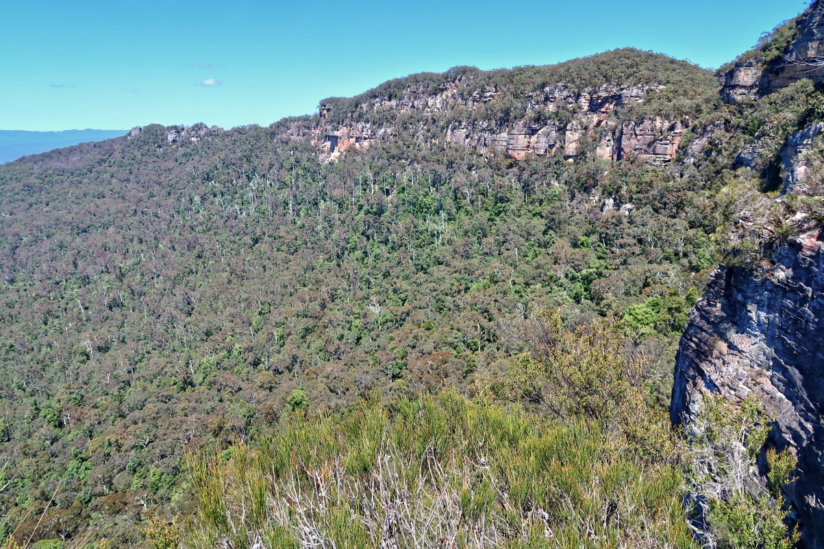
24) Along the way, we can see the middle peak of Mt Solitary, 919 meters, at the centre of this pic.
We won't be going to this high point. Roughly halfway between The Col and the high point, we'll turn north (to the right) to climb down Miners Pass.

25) A particularly steep section along the top of Mt Solitary ~~~
- Upper pic, left to right: John Fox, NC, LH, HT
- Lower pic, left to right: FM, Saf, HT, LH, NC, John Fox

26) Passing an overhang ~~~
After this overhang, in another 50 meters, we'll begin our descent down Miners pass.

Start of Miners Pass
27) The start of Miners Pass ~~~
It is down this steep gully.

Miners Pass
28) I've climbed down the passage in the previous pic, and now looking back at FM climbing down.

29) After the steep drop in the previous pic, we do a switchback and traverse eastward along the bottom of an escarpment.
- The 2 pics below are not of the same cliff face. But they are not too far from each other (about 100 meters apart).

30) Then it is another steep drop ... LH is at the start of it.

31) FM sliding down an even steeper section

32) Now approaching another steep descent ~~~
By the way, all along Miners Pass, there are cairns to guide you, like the one in the red circle in this pic.

33) I've climbed down to the bottom of the rock cliff (the top of which is the previous pic); and now looking back at FM climbing down.

34) This pic is taken at where I was standing in the previous pic ~~~
HT has set up a tape, and now proceeds to climb down.

35) I've climbed down the tape; and now looking back at FM climbing down.
- Lower pic: It is a tricky area. We need to crawl through it. John Fox is keeping an eye out for FM in case she needs help.

36) Everyone has climb down, and so HT is putting away his tape.

37) After the tape, it is walking along the base of an escarpment for a little while before another descent.
- Red square: The lower pic zooms into the square.
- Lower pic: This plant grows sideways out of the cliff face, how interesting ! And one of the branch is encased in a spider web.

38) Descending
- Upper pic, left to right: NC, Saf, John Fox, HT
- Lower pic, left to right, HT (left edge), John Fox, FM, Saf, NC, LH

39) FM starring in this last steep descent, after which the terrain will be much flatter.

To Kedumba River
40) We've finished descending Mt Solitary; and now walking on a flatter terrain towards Kedumba River.

41) Time to have lunch ~~~
Left to right: Saf, FM, LH, John Fox, HT

42) Lunch is over, back on our feet.
- Like photo #40, the terrain is quite flat.
- Upper pic, left to right: HT, John Fox, NC, FM
- Lower pic: FM

43) We walk along the top of a ridge towards Kedumba River. Most of the time it is quite flat as shown in the previous pics. Occasionally, here for example, it is like a razor blade. We can see the slope dropping off on both sides of the ridge.
- Left to right: HT, John Fox, LH

44) Shed skin of a snake

45) NC has a superficial scratch to his hand, and ...

46) ... and he should be given an Oscar for acting :-)

47) NC has his hand bandaged up by Saf (lower pic) so he can tell his wife he can't do the dishes because of a broken hand :-)

48) At the same spot as where the previous pic is taken ~~~
Even a Lace Monitor (Varanus varius) comes out to investigate NC's hand.

49) A beautiful Grevillea asplenifolia

Kedumba River
50) We reach Kedumba River ... FM is crossing it now.

51) I am at where FM was in the previous pic, and looking at HT ahead of me.

We have afternoon tea by the side of the river.
52) HT also has a superficial scratch on his hand and was promptly attended to by Saf.
Geez, real men don't need bandages ... we are becoming a bunch of softies :-)

53) Still having afternoon tea by the side of Kedumba River ~~~
You just have to love NC's colourful shoe. The shoe lace was bought separately to match the colours !

On our way to the cars
54) Grass Trees are blooming at this time of the year.

55) We are now on Kedumba Valley Road, west of the junction with the foot track to Mt Solitary.

56) We take a rest at the junction of Kedumba Valley Road and the foot track to Mt Solitary ~~~
- Upper pic, left to right: FM, Paul, HT, NC, LH
- Lower pic: Paul, HT, Saf, NC, LH
- John Fox is too fast and too far ahead of us, and misses out on the group photos :-)

57) Back at the feral pig control gate on Kedumba Valley Road ... same gate as photo #3

Carpark by the side of Kedumba Pass Gate
9 hours after we started this morning, we are back at the carpark by the side of Kedumba Pass Gate.
58) FM is with her brand new one week old car. It's a surprise she is willing to drive it on a dirt road to here. Ah, the passion for an adventure out weighs everything !

Thank you
Many thanks to HT for leading. His navigation skill is superb.
Your write up proved invaluable today, thank you. The Miners Pass has been washed out and obscured by falling trees in places, so the only way we were able to discern a sensible descent in a reasonable amount of time was to use your photos. Thanks again!
ReplyDeleteJohn (and Brendan)
Thank you for your comment. Good to know this trip report is useful to you :-)
DeleteThanks for your trip report. In your opinion what would it me like to reverse the miners pas- go up it from the river?
ReplyDeleteMay be even easier, as it is easier to spot a passage up a cliff than down a cliff. I assume you are more agile than the average bushwalker and you are able to climb up steep cliffs.
Delete