2016 December: One day climb to:
- Tenison Woods Knoll (also known as Watsons Crag Dome or Mt Dubious)
- Watsons Crags
- Mt Twynam
- Mt Anton
in Kosciuszko National Park, NSW, Australia
Prolog - A2K peaks, the 33 highest peaks in Australia
I have compiled a list of all the peaks in Australia that are 2000 meters or higher. There are 33 of them, all bunched together in Kosciuszko National Park. I am calling the list Paul Ma's A2K peaks :-)
Rank Name Elev Grid Ref
1 Mt Kosciuszko 2228 m 132 647
2 Mt Townsend 2209 m 128 684
3 Mt Twynam 2196 m 179 716
4 Rams Head 2190 m 128 608
5 Etheridge Ridge 2180 m 140 644
6 Rams Head North 2177 m 137 618
7 Alice Rawson Peak 2167 m 132 692
8 Byatts Camp 2159 m 118 676
9 Abbott Peak 2145 m 122 678
10 Carruthers Peak 2145 m 157 698
11 Tenison Woods Knoll 2136 m 166 719
12 Mt Northcote 2131 m 146 676
13 Little Twynam 2130 m 185 711
14 Muellers Peak 2125 m 138 673
15 Mt Clarke 2110 m 154 672
16 Mt Lee 2105 m 152 688
17 Kangaroo Ridge 2077 m 182 644
18 Mt Tate 2068 m 214 760
19 Gungartan 2068 m 258 835
20 Mt Jagungal 2062 m 248 987
21 Mt Perisher 2054 m 243 697
22 Mt Stilwell 2054 m 187 659
23 South Rams Head 2052 m 116 588
24 Kerries Ridge 2050 m 262 851
25 Little Stilwell 2030 m 190 657
26 Merritts Spur 2030 m 160 626
27 Toolong Range 2025 m 258 988
28 Watsons Crags 2021 m 161 733
29 Back Perisher Mtn 2014 m 247 708
30 Mt Anton 2010 m 191 727
31 The Foxhole 2010 m 198 661
32 Mann Bluff 2005 m 208 754
33 Dicky Cooper Bogong 2003 m 232 832
How the list is compiled:
- If a peak has a name, and is 2000 meters or higher, then include the peak in the list.
- If a range/ridge/spur has a name, and its highest point is 2000 meters plus, then include the highest point.
For more information on the list, including data source, please click on this link:
http://mntviews.blogspot.com.au/p/paul-mas-a2k-peaks.html
Today's A2K climb: Twynam, Tenison Woods Knoll, Watsons Crags, Anton
Continuing my effort to climb all these A2K peaks ... Today's climb with AB is to:
Rank Name Elev Grid Ref Comment
3 Mt Twynam 2196 m 179 716
11 Tenison Woods Knoll 2136 m 166 719 Watsons Crag Dome or Mt Dubious
28 Watsons Crags 2021 m 161 733
30 Mt Anton 2010 m 191 727
Other A2K climbing trips
Scroll forward to the end of this trip report. There is a list, with links, to other A2K climbing trips that I have done.
Maps
1:100,000 8525 Kosciuszko
1:50,000 Kosciuszko Alpine Area map, 1st edition, by Spatial Vision Innovations Pty Ltd
1:25,000 8525-2S Perisher Valley
Tenison Woods Knoll is not marked on any of the above maps. It is the 2136-meter peak west of Mt Twynam.
The relevant part of the 1:50,000 scaled map is:

The relevant part of the 1:25,000 scaled map is:

GPS tracklog file & Route
Our GPX tracklog file can be downloaded from:
https://drive.google.com/file/d/0B877-h5SCJaSUng3a0piWjhKYjg/view?usp=sharing
Below is the same tracklog, red colour, clockwise direction, superimposed on the 1:25,000 scaled map.

Satellite image of the tracklog in red colour, clockwise direction:

In summary, our route is:
- Park car at Charlotte Pass
- Cross Snowy River and Club Lake Creek
- Walk on Main Range Track to the T-junction with Club Lake Walk
- To Tenison Woods Knoll
- To Watsons Crags
- Retrace steps back to Tenison Woods Knoll
- To Mt Twynam
- To Mt Anton
- Pass the east side of Little Twynam
- Pass the east side of Hedley Tarn
- Back to the car at Charlotte Pass
Timeline & Distance
08:19 0.0 km Start at Charlotte Pass carpark
08:29 0.7 km Crossing Snowy River
08:31 0.8 km Crossing Club Lake Creek at where it joins the Snowy River
09:19 3.9 km At T-junction of Main Range Track & Blue Lake Walk
09:20 3.9 km Resume walking
09:35 4.8 km At T-junction of Main Range Track & turn off to Mt Twynam
09:37 4.8 km Resume walking
10:11 6.6 km Go off track towards Tenison Woods Knoll
10:27 7.3 km At Tenison Woods Knoll summit
10:38 7.3 km Leave Tenison Woods Knoll summit
11:06 8.8 km At Watsons Crags summit(?) which is marked by a steel post.
11:20 8.8 km Leave steel post at Watsons Crags and start to retrace steps back to Tenison Woods Knoll
11:22 8.9 km At a boulder which is higher than the steel post at Watsons Crags
11:24 8.9 km Leave boulder
11:28 9.1 km At a rocky outcrop which is higher than the steel post at Watsons Crags
11:30 9.1 km Leave rocky outcrop
11:58 10.0 km Back at Tenison Woods Knoll summit
12:36 11.9 km At Mt Twynam summit
Lunch
13:31 12.2 km Leave Mt Twynam summit
13:47 12.9 km At a rocky outcrop on a ridge north-east of Mt Twynam
Explore around
14:01 13.0 km Leave rocky outcrop
14:14 13.4 km At another rocky outcrop on a ridge north-east of Mt Twynam
14:18 13.4 km Leave rocky outcrop
14:43 14.3 km At Mt Anton summit
14:51 14.4 km Leave Mt Anton summit
15:14 15.0 km Crossing Ponds Creek
15:33 15.9 km Crossing Twynam Creek
16:24 18.4 km Crossing Blue Lake Creek
16:42 18.8 km Crossing Carruthers Creek
17:05 20.1 km At Main Range Track
17:11 20.5 km Crossing Club Lake Creek at where it joins the Snowy River
17:12 20.6 km Crossing Snowy River
17:25 21.3 km Back at Charlotte Pass carpark
==============================================
Total: 9 hrs 06 mins
21.3 km Distance is from Google Earth
22.7 km Distance is from Garmin GPS
Pictures - Charlotte Pass
1) We arrive here at Charlotte Pass at 8:10 am and the place is already full of cars.

To confluence of Snowy River & Club Lake Creek
2) Heading down Main Range Track towards the confluence of Snowy River & Club Lake Creek ~~~
- The shadows of AB and I make us look like we are stalking these 2 young women :-)
By the way, they are not twins. The one on the left is an Asian. On her right is a Caucasian. But they are dressed exactly the same. Both have the same hair style and colour :-)
Anyway, we won't be stalking them for long. We will overtake them soon.
- The 5 red arrows point to, from left to right:
1 Mt Clarke (due west)
2 Mt Northcote
3 Mt Townsend
4 Mt Lee
5 Carruthers Peak

3) A wonderful view of Club Lake Creek flowing into Snowy River at the centre of the pic ~~~
- Of the two rivers on the left side of the pic, Club Lake Creek is further away.
- The 2 peaks in the background:
1 Mt Lee (on the left)
2 Carruthers Peak (near the centre)
- We are walking on the Main Range Track and soon will cross both the Snowy River & Club Lake Creek near their confluence (see photo #4). Then we'll continue uphill along the track.

Confluence of Snowy River & Club Lake Creek
4) AB crossing Snowy River (upper pic), then Club Lake Creek (lower pic) ~~~
- Lower pic: On the river bank, a guy (standing) is waiting for his climbing companion to put on her boots ... because she took them off while crossing the creek. We can't figure out why did she want to take them off ??? ... because she won't get her boots wet by stepping on the stones. Anyway, these two are fast. Even though AB and I are not slow, we are not able to catch up with them.

To the junction of Blue Lake Walk
5) A marvellous view of Kangaroo Ridge (left side of the pic) and Kosciuszko Main Range (Click on the image to enlarge it.) ~~~
- Yellow arrow: We were walking on the track to here.
- The 11 red arrows point to, from left to right:
1 The Foxhole
2 Little Stilwell
3 Mt Stilwell
4 Labelled as rocky peak #1 in my trip report to Mt Stilwell 2 weeks ago ... Click on this link:
http://mntviews.blogspot.com.au/2016/12/mt-stilwell-and-kangaroo-ridge.html
5 Labelled as rocky peak #2 in my trip report to Mt Stilwell
6 Rams Head North
7 Etheridge Ridge highest peak (unnamed)
8 Mt Clarke
9 Mt Northcote (due west)
10 Mt Lee
11 Carruthers Peak
- Mt Kosciuszko is a bit to the right of Etheridge Ridge highest peak. But it is behind the range in the front and hence can't be seen from here.

6) Crossing a snow patch ~~~
We can't see Mt Twynam yet.

7) Carruthers Creek ~~~
- Upper pic: We can just see the couple (of photo #4) way ahead of us on the other side of the creek.
- Lower pic: I've crossed Carruthers Creek, now looking back at AB.

At the junction of Blue Lake Walk
We've been walking towards the north and now come to a T-junction. Going east is to Blue Lake on the Blue Lake Walk track.
8) Blue Lake is one of only five glacial tarns in mainland Australia. The other four are Lake Cootapatamba, Lake Albina, Club Lake and Hedley Tarn. We won't be going to Blue Lake today. But later in the afternoon, we'll go pass Hedley Tarn.
- Upper pic:
• Blue arrow: Track to Blue Lake ... We won't be going there. In fact, we'll be going in the opposite direction.
• The 3 red arrows point to, from left to right:
1 Little Twynam (towards north-east)
2 Back Perisher Mountain
3 Mt Perisher (towards east)
• Continuation to the right of this pic is photo #9.
- Lower pic: The 2 red arrows point to, from left to right:
1 Back Perisher Mountain
2 1987-meter peak marked as Sma 0318 (the mountain in the foreground, towards east)

9) Still at the T-junction ~~~
These are bags of rocks ... looks like some work is being done on paving the track.
- Upper pic:
• Continuation to the left of this pic is photo #8.
• Yellow arrow on the left edge: We came from that direction (south).
• Blue arrow: Track to Blue Lake ... We won't be going there.
• We can just see the couple (of photo #4) way ahead of us. We are going there too (towards west, in the opposite direction to Blue Lake). The couple are fast ... even though AB and I are not slow, we are not able to catch up with them.
- Lower pic:
• Red arrow points to Mt Twynam. We'll climb it later on. (The first 2 peaks we'll climb are Tenison Woods Knoll and Watsons Crags. Afterwards, the 3rd peak for today is Mt Twynam.)
• Continuation to the right of this pic is photo #8.

To Tenison Woods Knoll
From the T-junction, we walk towards west, to where the couple is in photo #9.
10) At about 200 meters west of the T-junction, and looking back ~~~
- The largish hill in the middle of the pic is about 2010 meters and is unnamed.
- Yellow oval & yellow arrows: It is the Main Range Track. We walked on it to reach here.
- Yellow circle: The T-junction which is the start of Blue Lake Walk track that goes to Blue Lake
- The 6 red arrows point to, from left to right:
1 Little Twynam (towards north-east)
2 Back Perisher Mountain
3 Mt Perisher (towards east)
4 The Foxhole
5 Little Stilwell
6 Mt Stilwell (towards south-south-east)
- The mountain range to the right of Little Twynam is Crummer Spur.

11) This interesting rock formation, at about 500 meters west of the T-junction, looks like a dragon or the spine of a dinosaur. I took a similar and a better picture of it in photo #13 in
http://mntviews.blogspot.com.au/2015/03/sentinel-nsw-australia.html
(Continuation to the left of this pic is photo #12.)

12) A snow patch to be crossed ~~~
- Upper pic:
• The couple is in front of us.
• Continuation to the right of this pic is the previous one.
- Lower pic: About to cross the snow patch

13) At last, we catch up with the couple ... only because they are taking rest :-)
- Red arrow: Mt Sentinel ... AB and I went there in 2015 March. Photos and trip report are in:
http://mntviews.blogspot.com.au/2015/03/sentinel-nsw-australia.html

14) At the same spot as where the previous pic was taken ~~~
You can see the Main Range Track winding its way towards the big mountain, Carruthers Peak, south-west-ish. We won't be going there today. Instead, we'll go in the opposite direction. Our first peak is Tenison Woods Knoll.

15) Still at the same spot as where the previous 2 pics were taken ~~~
This is where we are going:
- Left red arrow: Watsons Crags
- Right red arrow: Tenison Woods Knoll
- The track you can see in this pic is not marked on any map ... strange! Anyway, we are going to walk along it now.

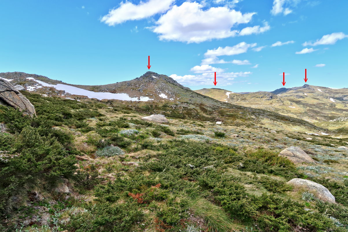
16) We've walked for another 450 meters since the previous photo was taken.
- Upper pic:
• Yellow arrow: We walked along the track to here. This track is not marked on any map that I know.
• The 5 red arrows point to, from left to right:
1 Mt Kosciuszko
2 Carruthers Peak
3 Mt Townsend
4 Alice Rawson Peak
5 Mt Sentinel
- Lower pic (continuation to the right of the upper pic):
• The 2 red arrows point to, from left to right:
1 Tenison Woods Knoll
2 Mt Twynam
• Watsons Crags can't be seen from here. It is behind the left slope of Tenison Woods Knoll.
• We'll soon walk along the yellow arrow, then go behind the knoll between the 2 red arrows, then climb to the summit of Tenison Woods Knoll.

17) Tenison Woods Knoll is the mountain at the centre of the pic.
Watsons Crags can't be seen from here. It is behind the knoll to the right of Tenison Woods Knoll.

18) Closer to Tenison Woods Knoll ~~~
The 3 red arrows point to, from left to right:
1 Mt Townsend
2 Alison Rawson Peak
3 Tenison Woods Knoll

19) Very close to Tenison Woods Knoll summit now ~~~
- Upper pic:
• The 7 red arrows point to, from left to right:
1 Rams Head North
2 Etheridge Ridge highest peak (unnamed)
3 Carruthers Peak
4 Mt Kosciuszko (towards south-south-west)
5 Muellers Peak
6 Mt Townsend
7 Alice Rawson Peak
• Mt Northcote & Mt Lee are behind Carruthers Peak, and can't be seen from here.
• Byatts Camp & Abbott Peak are behind Mt Townsend, and can't be seen from here.
- Middle pic (Continuation to the right of the upper pic):
• The 2 red arrows point to, from left to right:
1 Tenison Woods Knoll summit
2 Mt Jagungal
- Lower pic (Continuation to the right of the middle pic):
• The 4 red arrows point to, from left to right:
1 Mt Tate
2 Gills Knobs
3 An unnamed knoll north-north-east-ish of Mt Twynam
4 Mt Twynam (towards east)
• Mt Anton is behind the unnamed knoll and can't be seen from here.

Tenison Woods Knoll summit
20) At the summit of Tenison Woods Knoll, 2136 meters

21) Panorama from the summit of Tenison Woods Knoll ~~~
- Upper pic:
• The 7 red arrows point to, from left to right:
1 Rams Head North
2 Etheridge Ridge highest peak (unnamed)
3 Carruthers Peak
4 Mt Kosciuszko (towards south-south-west)
5 Muellers Peak
6 Mt Townsend
7 Alice Rawson Peak
• Mt Northcote & Mt Lee are behind Carruthers Peak, and can't be seen from here.
• Byatts Camp & Abbott Peak are behind Mt Townsend, and can't be seen from here.
- Lower pic:
• The 6 red arrows point to, from left to right:
1 Watsons Crags is just behind this knoll and can't be seen from here.
2 Mt Jagungal
3 Mt Tate
4 Gills Knobs
5 An unnamed knoll north-north-east-ish of Mt Twynam
6 Mt Twynam (towards east-south-east-ish) ... we can just see its summit trig.
• Mt Anton is behind the unnamed knoll and can't be seen from here.

22) It is strange there wasn't a cairn here at the summit.
- So we build one (red circle) on top the rock where AB was standing in photo #20.
- Watsons Crags is just behind the red oval and can't be seen from here.

To Watsons Crags
23) We've left the summit of Tenison Woods Knoll. About 500 metes later, we come across this note ... exactly the way we found it. Did the owner left it here? Or did someone else found it on the ground and weighed it down by a stone?
- The words on the note are:
Point 7
Arrival: 10:05
All is well, every one
is enjoying the view.
- A large reddish fly is also snapped in this pic ... I haven't seen a fly like this before !

24) Beautiful scene of Watsons Crags ~~~
There is a steel post at the red arrow marking roughly the middle of Watsons Crags ... see photos #27 and #28.

25) Approaching Watsons Crags ~~~
We'll climb over these rocks. Where we want to go is behind them.

We've climbed over the rocks of the previous pic.
26) This is our destination.
- Upper pic: The rocks in the red circle and blue oval are the highest points around this area of Watsons Crags. The rocks in the blue oval seems a bit higher.
- Lower pic: Red arrow points to a steel post. We are going there first. (That place is lower than the aforementioned rocks.)

Watsons Crags
27) We are going to the steel post first.

28) Having our photos taken ... at 2021 meters ~~~
- The 4 red arrows point to, from left to right:
1 Carruthers Peak
2 Mt Northcote
3 Mt Kosciuszko
4 Muellers Peak
- Small red dot: Mt Sentinel
- Mt Townsend & Alice Rawson Peak are not visible ... blocked by me :-) ... but see photos #29 and #30.

29) The 3 pics below form a 360-degree panorama from the steal post at Watsons Crags:
- Upper pic:
• The 6 red arrows point to, from left to right:
1 Carruthers Peak
2 Mt Northcote
3 Mt Kosciuszko
4 Muellers Peak
5 Mt Townsend
6 Alice Rawson Peak
• Small red dot: Mt Sentinel
• Byatts Camp & Abbott Peak are behind Mt Townsend, and can't be seen from here.
- Middle pic (Continuation to the right of the upper pic):
• The 2 red arrows point to, from left to right:
1 Mt Jagungal
2 Mt Tate
- Lower pic (Continuation to the right of the middle pic):
• The 4 red arrows point to, from left to right:
1 Blue Cow Mountain
2 Mt Twynam
3 Tenison Woods Knoll
4 Carruthers Peak
• Red circle: Same as the red circle in photo #26, one of the highest points in the vicinity of this area.
• Blue oval: Same as the blue oval in photo #26, the highest point in the vicinity of this area.
• Mt Anton can't be seen from here. The line of sight is blocked by the rock in the red circle.
• Photo #30 zooms into the left side of this pic.
- Continuation to the right of the lower pic is the upper pic, thus completing a 360-degree panorama.

30) Still at the steel post of Watsons Crags ~~~
Zooming into parts of photo #29:
- Upper pic: We came to Watosons Crags from this direction.
• The 3 red arrows point to, from left to right:
1 Mt Tate
2 Blue Cow Mountain
3 Mt Twynam
• Red circle: Same as the red circle in photos #26 and #29, one of the highest points in the vicinity of this area. We are going there next.
• Blue oval: Same as the blue oval in photos #26 and #29, the highest point in the vicinity of this area.
• Mt Anton can't be seen from here. The line of sight is blocked by the rock in the red circle.
- Lower pic (Continuation to the right of the upper pic):
• The 7 red arrows point to, from left to right:
1 Tenison Woods Knoll
2 Carruthers Peak
3 Mt Northcote
4 Mt Kosciuszko
5 Muellers Peak
6 Mt Townsend
7 Alice Rawson Peak
• Small red dot: Mt Sentinel
• Byatts Camp & Abbott Peak are behind Mt Townsend, and can't be seen from here.

Watsons Crags highest points
We now turn around and return to Tenison Woods Knoll ...
31) ... but first, we are going to climb up the big rock at the centre of this pic ... the same rock as the one in the red circle of photos #26, #29, #30.

32) We are on top of the rock of the previous pic.
- The rock in both pics below are of the same rock, viewed from different directions.
- This place is higher than the steel post in photos #27 and #28.

33) Next, we go to this pile of rocks. It is the same pile as the one in the blue oval in photos #26, #29, #30, and is the highest point around here at Watsons Crags.

34) Well, we are at the highest point around this area.

Return to Tenison Woods Knoll
35) On our way back to Tenison Woods Knoll ~~~
- Upper pics:
• The 4 red arrows point to, from left to right:
1 Blue Cow Mountain
2 Mt Anton
3 Mt Twynam
4 Tenison Woods Knoll
- Lower pic: We've walked closer to Tenison Woods Knoll.
• The 6 red arrows point to, from left to right:
1 Tenison Woods Knoll
2 Carruthers Peak
3 Mt Kosciuszko
4 Muellers Peak
5 Mt Townsend
6 Alice Rawson Peak

36) Closer again to Tenison Woods Knoll (Click on the image to enlarge it.) ~~~
- Blue arrow on the left edge: Mt Anton
- Turquoise arrow on the right: We can just barely see the tip of Mt Sentinel.
- The 8 red arrows point to, from left to right:
1 Blue Cow Mountain
2 Mt Twynam
3 Tenison Woods Knoll
4 Carruthers Peak
5 Mt Kosciuszko
6 Muellers Peak
7 Mt Townsend
8 Alice Rawson Peak

37) Climbing up Tenison Woods Knoll
In both pics below:
- Left red arrow: Mt Twynam
- Right red arrow: Tenison Woods Knoll summit

Small yellow flower
We've climb over Tenison Woods Knoll, now on the way to Mt Twynam.
38) This small yellow flower is photographed near the saddle between Tenison Woods Knoll & Mt Twynam.

To Mt Twynam
We've passed the saddle between Tenison Woods Knoll & Mt Twynam, and are now on our way to the latter.
39) Looking back at where we came from:
- Left red arrow: Tenison Woods Knoll
- Right red arrow: Watsons Crags

40) We can see Mt Twynam's summit trig.

41) Not far from Mt Twynam summit ~~~
- Upper pic: High school kids coming down from Mt Twynam; about 10 of them ... They are on the 7th day of an 8-day hike from Jagungal. WOW! Tomorrow, they'll finish at Dead Horse Gap.
- Lower pic: The kids are accompanied by 2 teachers who are much further behind ... no match for the young kids !

Mt Twynam summit
42) Mt Twynam summit, 2196 meters ... 3rd peak for today, also the 3rd highest peak on the Australian main land

43) Photo time at Mt Twynam summit ~~~
- The 5 red arrows point to, from left to right:
1 Mt Kosciuszko
2 Muellers Peak
3 Carruthers Peak
4 Mt Townsend
5 Alice Rawson Peak
- In front of and lower than Muellers Peak is Mt Lee. Its colour blends in with the slope of Muellers Peak and is almost not possible to identify it.

44) The 3 pics below form a 360-degree panorama from the summit of Mt Twynam:
- Upper pic:
• The 3 red arrows point to, from left to right:
1 Blue Cow Mountain (towards east)
2 Back Perisher Mountain
3 Mt Perisher (towards east-south-east)
• Photo #45 zooms into the left side of this pic.
- Middle pic (Continuation to the right of the upper pic):
• The 10 red arrows point to, from left to right:
1 Rams Head North
2 Rams Head
3 Etheridge Ridge highest peak (unnamed)
4 Mt Kosciuszko
5 Mt Northcote (towards south-west)
6 Muellers Peak
7 Carruthers Peak
8 Mt Townsend
9 Alice Rawson Peak
10 Tenison Woods Knoll (towards west)
• Byatts Camp & Abbott Peak are behind Mt Townsend, and can't be seen from here.
• In front of and lower than Muellers Peak is Mt Lee. Its colour blends in with the slope of Muellers Peak and is almost not possible to identify it.
• Photo #45 zooms into the Kosciuszko Main Range.
- Lower pic (Continuation to the right of the middle pic):
• The 3 red arrows point to, from left to right:
1 Watsons Crags is behind this boulder (towards north-west).
2 Mt Jagungal
3 Mt Tate (towards north-east)
- Continuation to the right of the lower pic is the upper pic, thus completing a 360-degree panorama.

45) Zooming into parts of photo #44 ~~~
- Upper pic:
• The 3 red arrows point to, from left to right:
1 Blue Cow Mountain (towards east)
2 Back Perisher Mountain
3 Mt Perisher (towards east-south-east)
- Lower pic:
• The 10 red arrows point to, from left to right:
1 Rams Head North
2 Rams Head
3 Etheridge Ridge highest peak (unnamed)
4 Mt Clarke
5 Mt Kosciuszko
6 Mt Northcote (towards south-west)
7 Muellers Peak
8 Carruthers Peak
9 Mt Townsend
10 Alice Rawson Peak
• Byatts Camp & Abbott Peak are behind Mt Townsend, and can't be seen from here.
• In front of and lower than Muellers Peak is Mt Lee. Its colour blends in with the slope of Muellers Peak and is almost not possible to identify it.

46) We have lunch at the summit and I take some photos of these small yellow flowers.

To Mt Anton
47) Leaving Mt Twynam and looking back at its summit and the trig

48) On the north-eastern slope of Mt Twynam ~~~
Ken in the Comment Section said the fencing was from summer grazing leases. The cattlemen would bring sheep and cattle up and hoped that the weather didn't turn too bad. This practice was ended not by the creation of the national park, but by the hydro scheme. The grazing caused considerable erosion which would have silted up the dams. The landscape that we see today is much different from 200 years ago, as 1 to 2 metres of topsoil were lost, exposing more of the rocks.
Thanks Ken.

49) Along the spur to Mt Anton ~~~
Taking a panoramic view of the surrounding area:
- Upper pic, towards where we are going:
• The 8 red arrows point to, from left to right:
1 Mt Jagungal
2 Mann Bluff
3 Mt Tate
4 Gills Knobs
5 Mt Anton ... We are going there now.
6 Blue Cow Mountain
7 Back Perisher Mountain
8 Mt Perisher
- Lower pic (Continuation to the right of the upper pic):
• Looking back ... at the northern slope of Mt Twynam
• The 2 red arrows point to, from left to right:
1 Little Twynam
2 We came to here from where the arrow is pointing at. Mt Twynam's summit is further back and can't be seen from here.

50) Further along the spur to Mt Anton ... The 3 pics below form another panorama ~~~
- Upper pic, towards where we are going:
• The 7 red arrows point to, from left to right:
1 Mann Bluff
2 Mt Tate
3 Gills Knobs
4 Mt Anton ... We are going there now.
5 Blue Cow Mountain
6 Back Perisher Mountain
7 Mt Perisher
• Photo #51 zooms into the left side of this pic.
- Middle pic (Continuation to the right of the upper pic):
• Red arrow: Little Twynam
- Lower pic (Continuation to the right of the middle pic), looking back:
• Red arrow: Watsons Crags
• The large mountain on the left is the northern slope of Mt Twynam. The summit is further back and can't be seen from here.
• Tenison Woods Knoll can't be seen from here.

51) Walking towards Mt Anton ~~~
- In both pics below, the 7 red arrows point to, from left to right:
1 Mann Bluff
2 Mt Tate
3 Gills Knobs
4 Mt Anton ... We are going there now.
5 Blue Cow Mountain
6 ?
7 Guthega Peak
- Lower pic: More of the fences from summer grazing leases in the bygone eras ... we first noticed them in photo #48.

52) Small white flower found along the way ~~~
Does anyone know its name ?

53) Looking back at where we came from ~~~
- Yellow arrows: How we reach where we are now
- 3 red arrows point to, from left to right:
1 Little Twynam
2 Mt Twynam summit is somewhere behind the red arrow and can't be seen from here.
3 Watsons Crags

54) Towards Mt Anton ~~~
- Yellow arrow: The route we'll take to climb up to the summit of Mt Anton.
- The 6 red arrows point to, from left to right:
1 Mann Bluff
2 Mt Tate
3 Mt Anton ... We are going there now.
4 Blue Cow Mountain
5 Guthega Peak

55) Closer to Mt Anton ~~~
- Yellow arrows: The route we'll take to climb up to the summit of Mt Anton
- The 3 red arrows point to, from left to right:
1 Mann Bluff
2 Mt Tate
3 Mt Anton

Climbing up to Mt Anton summit
56) AB climbing up to Mt Anton summit ... along the yellow arrows

57) AB climbing up to Mt Anton summit

58) One more scramble and we'll be at the top of Mt Anton ~~~
The red arrows in both pics below point to the same rock feature.

Mt Anton summit
59) AB and I at the summit of Mt Anton, 2010 meters.

60) The 3 pics below form a 360-degree panorama from the summit of Mt Anton:
- Upper pic:
• The 5 red arrows point to, from left to right:
1 Little Twynam
2 Mt Twynam summit is a bit further back and can't be seen from here. (Towards south-west)
3 Knoll along ridge running towards north-east from Mt Twynam. We walked through there on the way to Mt Anton.
4 Another knoll along ridge running towards north-east from Mt Twynam. We walked through there on the way to Mt Anton.
5 Watsons Crags
• Tenison Woods Knoll can't be seen from here.
• Photo #61 zooms into the centre part of this pic.
- Middle pic (Continuation to the right of the upper pic):
• The 5 red arrows point to, from left to right:
1 Mt Jagungal
2 Mt Anderson
3 Mann Bluff
4 Mt Tate
5 Gills Knobs (towards north-east)
- Lower pic (Continuation to the right of the middle pic):
• The 5 red arrows point to, from left to right:
1 Gills Knobs (towards north-east)
2 Blue Cow Mountain
3 Guthega Peak
4 Back Perisher Mountain
5 Mt Perisher
- Continuation to the right of the lower pic is the upper pic, thus completing a 360-degree panorama.

61) Zooming into parts of photo #60 ~~~
- Upper pic:
• The 2 red arrows point to, from left to right:
1 Little Twynam
2 Mt Twynam summit is further back and can't be seen from here. (Towards south-west)
• The 3 yellow arrows: We walked through these points on the way to here at the summit of Mt Anton.
- Lower pic:
• The 6 red arrows point to, from left to right:
1 Mt Anderson
2 Mann Bluff
3 Mt Tate
4 Gills Knobs (towards north-east)
5 Blue Cow Mountain
6 Guthega Peak

To Hedley Tarn
62) Climbing down the summit of Mt Anton and looking back at it

63) We've climbed down from Mt Anton ... looking back at it and the snow patch we just crossed.
- Left red arrow: Mt Anton
- Right red arrow: Blue Cow Mountain
- The foot prints on the snow are ours.

64) Looking at Little Twynam (left arrow) and Mt Twynam (right arrow) ~~~
We'll skirt pass the left (east) side of Little Twynam to Hedley Tarn.

65) Crossing the headwaters of Pounds Creek ~~~
- Red oval in both of the 2 pics below: They are of the same rock.
- Lower pic (Continuation to the right of the upper pic):
• Red arrow: Mt Anton
• Blue arrow: Pounds Creek starts here. (It flows into Guthega Pondage.)

66) (Click on the image to enlarge it.)
We've crossed Pounds Creek and is now about halfway between the headwaters of Pounds Creek and Twynam Creek.
This photograph is a nice panorama taking in Little Twynam, Mt Twynam, Mt Anton and Mt Anderson (the 4 red arrows from left to right).

67) Zooming into the right side of the previous pic ~~~
The 4 red arrows point to, from left to right:
- Mt Anton
- Mt Anderson
- Mann Bluff
- Mt Tate
68) AB near the headwaters of Twynam Creek ~~~
- Twynam Creek flows into Snowy River which flows into Guthega Pondage.
- Red arrow: The summit of Little Twynam is a little behind it and can't be seen from here.

Hedley Tarn
69) (Click on the image to enlarge it.)
After climbing over Crummer Spur, we are presented with this wonderful view of Hedley Tarn, Blue Lake and Kosciuszko Main Range.
- Hedley Tarn is the lake on the left; south-south-west of where we are. Photo #70 zooms into it.
- Blue Lake is the lake near the middle; directly west of where we are. Photo #71 zooms into it.
- The 9 red arrows point to, from left to right:
1 North Rams Head
2 Rams Head
3 Etheridge Ridge highest peak (unnamed)
4 Mt Kosciuszko
5 Mt Clarke
6 Mt Northcote
7 Mt Lee
8 Carruthers Peak
9 Little Twynam's summit can't be seen from here, but it is not far behind the arrow.

70) Zooming into Hedley Tarn on the left side of the previous pic ~~~
- Upper pic:
• Yellow arrows: We'll follow the yellow arrows back to the car at Charlotte Pass.
• The 10 red arrows point to, from left to right:
1 The Foxhole
2 Little Stilwell
3 Mt Stilwell
4 Labelled as rocky peak #1 in my trip report to Mt Stilwell ... click on this link:
http://mntviews.blogspot.com.au/2016/12/mt-stilwell-and-kangaroo-ridge.html
5 Labelled as rocky peak #2 in my trip report to Mt Stilwell.
6 North Rams Head
7 Rams Head is just behind the tiny bump in the pic.
8 Etheridge Ridge highest peak (unnamed)
9 Mt Kosciuszko
10 Mt Clarke
- Lower pic: The 5 red arrows point to, from left to right:
1 North Rams Head
2 Rams Head is just behind the tiny bump in the pic.
3 Etheridge Ridge highest peak (unnamed)
4 Mt Kosciuszko
5 Mt Clarke

71) Zooming into Blue Lake of photo #69 ~~~
- Red arrow: Carruthers Peak

72) We are now at the south-east side of Hedley Tarn ~~~
- The 3 red arrows point to, from left to right:
1 Carruthers Peak
2 Mt Twynam
3 Little Twynan
- Blue Lake is in the depression on the left side Little Twynam.

73) Passing by this large rock ~~~
Is the little rock on the top natural or purposely put there by someone ?

Crossing Blue Lake Creek
The water from Hedley Tarn flows into Blue Lake Creek which we need to cross.
74) A quiet pool just before we cross Blue Lake Creek ~~~
There are plenty of small fish in it.
The fish is Mountain Galaxias (Galaxias olidus), a native Australian which averages about 13 cm in length. It survives in the smaller streams above the treeline through its astonishing ability to jump out of the water and clamber up steep rocks and waterfalls. This fragile but acrobatic fish can also "walk" over rocks and splashes in shallow pools in order to regulate its body temperature.

75) Crossing Blue Lake Creek
- Upper pic: Up stream
- Lower pic: Down stream

76) AB crossing Blue Lake Creek

Crossing Carruthers Creek
77) We now cross Carruthers Creek (about 400 meters after crossing Blue Lake Creek).
This is the same Carruthers Creek as in photo #7, but much further down stream.

To carpark at Charlotte Pass
78) We climb half way up the slope south of Carruthers Creek, and take in the following panorama.
- Upper pic, looking back at where we just came from:
• The 2 red arrows point to, from left to right:
1 Mt Twynam
2 Little Twynam (directly north)
• Blue bar: Crummer Spur
• Yellow arrow: We came over Crummer Spur and walked along the yellow arrow to where we are now.
• Hedley Tarn: Not visible from here ... it is in the depression in front of Little Twynam and to the left of the yellow arrow.
- Lower pic (Continuation to the right of the upper pic):
• The 2 red arrows point to, from left to right:
1 Blow Cow Mountain (towards north-east-ish)
2 The Foxhole (towards south-south-east-ish)

79) We are still off-track ... but it won't be long now to get back to my car.
- Upper pic:
• Upper turquoise arrow: Snowy River
• Lower turquoise arrow: Club Lake Creek
• Turquoise circle: Behind the rock is the confluence of Snowy River & Club Lake Creek ... See photos #3 and #4.
• The 7 red arrows point to, from left to right:
1 Charlotte Pass carpark
2 The Foxhole
3 Little Stilwell
4 Mt Stilwell
5 Labelled as rocky peak #1 in my trip report to Mt Stilwell ... click on this link:
http://mntviews.blogspot.com.au/2016/12/mt-stilwell-and-kangaroo-ridge.html
6 Labelled as rocky peak #2 in my trip report to Mt Stilwell.
7 North Rams Head
• Yellow arrow: This morning, we walked down the track starting at Charlotte Pass. Photo #2 was taken near the start of the track.
- Lower pic (Continuation to the right of the upper pic):
• The 7 red arrows point to, from left to right:
1 Etheridge Ridge highest peak (unnamed)
2 Mt Kosciuszko
3 Mt Clarke
4 Mt Northcote
5 Mt Townsend just poking its tip above the Main Range ridge
6 Mt Lee
7 Carruthers Peak

80) We are back on the track leading down to the confluence of Snowy River & Club Lake Creek. In the pic, you can see the track that climbs up-hill back to Charlotte Pass carpark.
The 2 pics below form a 180 degree panorama:
- Upper pic:
• Upper turquoise arrow: Snowy River
• Lower turquoise arrow: Club Lake Creek
• Turquoise oval: Confluence of Snowy River & Club Lake Creek ... see photos #3 and #4.
• The 4 red arrows point to, from left to right:
1 Charlotte Pass carpark
2 The Foxhole is behind the arrow and can't be seen from here.
3 Mt Stilwell
4 Labelled as rocky peak #1 in my trip report to Mt Stilwell ... click on this link:
http://mntviews.blogspot.com.au/2016/12/mt-stilwell-and-kangaroo-ridge.html
• Yellow arrow: This morning, we walked down the track starting at Charlotte Pass. Photo #2 was taken near the start of the track.
- Lower pic (Continuation to the right of the upper pic):
• Red square: Photo #81 zooms into this area. (In photo #81, we can see a ruin, and people camping there.)
• The 4 red arrows point to, from left to right:
1 Etheridge Ridge highest peak (unnamed)
2 Mt Clarke
3 Mt Northcote
4 Mt Lee

81) Zooming into the red square of the previous pic ~~~
We can see a ruin, and people camping by the side of Club Lake Creek.
- I haven't been to the ruin. It would be interesting to walk pass it one day.
- Turquoise arrows from top to bottom: Snowy River & Club Lake Creek

Post script - Other A2K climbing trips
• 2017 November
Rank Name Elev Grid Ref
20 Mt Jagungal 2062 m 248 987
27 Toolong Range 2025 m 258 988
Trip report will be written up soon ... whatever that means :-)
In the mean time, if you like to know the details, contact me.
• 2017 January with AB
Rank Name Elev Grid Ref
18 Mt Tate 2068 m 214 760
32 Mann Bluff 2005 m 208 754
Photos and trip report are in my blog:
http://mntviews.blogspot.com.au/2017/01/mt-tate-mann-bluff-gills-knobs.html
• 2016 December with AB
Rank Name Elev Grid Ref Comment
3 Mt Twynam 2196 m 179 716
11 Tenison Woods Knoll 2136 m 166 719 Watsons Crag Dome or Mt Dubious
28 Watsons Crags 2021 m 161 733
30 Mt Anton 2010 m 191 727
This trip report :-)
• 2016 December with AB & DN
Rank Name Elev Grid Ref Comment
17 Kangaroo Ridge 2077 m 182 644 Morning
21 Mt Perisher 2054 m 243 697 Afternoon
22 Mt Stilwell 2054 m 187 659 Morning
25 Little Stilwell 2030 m 190 657 Morning
29 Back Perisher Mtn 2014 m 247 708 Afternoon
31 The Foxhole 2010 m 198 661 Morning
Photos and trip reports are in my blog:
- Morning: http://mntviews.blogspot.com.au/2016/12/mt-stilwell-and-kangaroo-ridge.html
- Afternoon: http://mntviews.blogspot.com.au/2016/12/mt-perisher-back-perisher-mtn.html
• 2015 October with RZ
Rank Name Elev Grid Ref
33 Dicky Cooper Bogong 2003 m 232 832
Photos and trip report are in my blog:
http://mntviews.blogspot.com.au/2015/10/dicky-cooper-bogong-granite-peaks-nsw.html
• 2015 March with AB, DN & Saf
Rank Name Elev Grid Ref
19 Gungartan 2068 m 258 835
24 Kerries Ridge 2050 m 262 851
Photos and trip report are in my blog:
http://mntviews.blogspot.com.au/2015/03/gungartan-kerries-ridge-nsw-australia.html
• 2014 December with AB & DN
Rank Name Elev Grid Ref Comment
1 Mt Kosciuszko 2228 m 132 647
2 Mt Townsend 2209 m 128 684 Abbott Range
7 Alice Rawson Peak 2167 m 132 692 Abbott Range
8 Byatts Camp 2159 m 118 676 Abbott Range
9 Abbott Peak 2145 m 122 678 Abbott Range
10 Carruthers Peak 2145 m 157 698
12 Mt Northcote 2131 m 146 676
wrong Byatts Camp 2110 m 116 671 Abbott Range
15 Mt Clarke 2110 m 154 672
16 Mt Lee 2105 m 152 688
Photos and trip report are in my blog:
http://mntviews.blogspot.com.au/2014/12/lee-northcote-clarke-abbott-range.html
• 2014 November with AB & DN
Rank Name Elev Grid Ref
1 Mt Kosciuszko 2228 m 132 647
4 Rams Head 2193 m 128 608
5 Etheridge Ridge 2180 m 140 644
6 Rams Head North 2177 m 137 618
23 South Rams Head 2052 m 116 588
Photos and trip report are in my blog:
http://mntviews.blogspot.com.au/2014/11/etheridge-ridge-kosciuszko-rams-head.html
• 2014 April with DH
Rank Name Elev Grid Ref
1 Mt Kosciuszko 2228 m 132 647
2 Mt Townsend 2209 m 128 684
3 Mt Twynam 2196 m 179 716
10 Carruthers Peak 2145 m 157 698
13 Little Twynam 2130 m 185 711
and incidentally bagging 3 highest peaks of Australia in one day. Photos and trip report are in my blog:
http://mntviews.blogspot.com.au/2014/04/kosciuszko-townsend-twynam-carruthers.html
• 2011 April with RE
Rank Name Elev Grid Ref
1 Mt Kosciuszko 2228 m 132 647
2 Mt Townsend 2209 m 128 684
14 Muellers Peak 2125 m 138 673
Photos and trip report are in my blog:
http://mntviews.blogspot.com.au/2011/04/kosciuszo-muellers-peak-townsend-nsw.html
The fencing is from summer grazing leases. The cattlemen would bring sheep and cattle up and hope that the weather didn't turn too bad. This was ended not by the creation of the national park, but by the hydro scheme. The grazing caused considerable erosion which would have silted up the dams. The landscape that you see today is much different from 200 years ago, as 1 to 2 metres of topsoil were lost, exposing more of the rocks.
ReplyDeleteThanks Ken. When I have a spare moment, I'll incorporate your comment into the report.
Delete